
Table of Contents
ToggleHow to make a demarcation sketch:
A copy of the village map is cut into pieces, or 10 to 15 survey numbers on each sheet of FMB-sized drawing paper, the scale of the fields being approximately 1 CM=2 1/2 chains. All the sketches made for the whole survey numbers of the village will be bound as a book. The boundaries of the field in the D-sketch should be drawn as continuous lines. Wherever there is a subdivision in any survey number, the subdivision lines should be drawn with a pencil and the field and subdivision line measurements should be recorded as far as possible. The subdivision of Poramboke fields should be drawn with red dotted lines. Poramboke subdivisions and Poramboke fields in the D-sketch should be marked with the red letter P.
I. How to Assign Stone Numbers in a Demarcation Sketch:
- All A-Class stones in the village should be given the same serial number in the Anticlockwise direction. Numbers for B-class stones should be given in a clockwise direction in red on each survey number.
- The numbering should be started at the northwest corner and numbering should be given to all stones of the field boundary after that numbering should be given to stones of Poramboke subdivisions.
- The stones that come in each survey number should be counted with separate serial numbers. (One Serial for each survey No.)Stones should be counted only on the lowest numbered survey number.
- When calculating B-class stones for survey numbers on a village, taluka, and district boundaries, those stones should be counted in the village where the stones are to be preserved even in the least numbered village.
II. Demarcation Sketch Uses:
- Details of the amount of A and B class stones that we need to regularly inspect and maintain in a village should be known.
- This is very useful in inspecting the field as the line measurements and sub-divisions measurements are there in the D-sketch. After the D-sketch is made, the registers of stones A and B are made with the help of the D-sketch.
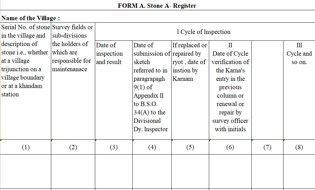
A. Procedure for making A-Class Stone Register:
This register should show the total A-class stones planted in the village. The number given in the D-sketch for that stone in the first column of the register and the stone description ( i.e. village trijunction, Pointer) details should be written. The survey number and sub-division number responsible for maintaining the stone should be written in the second column. The date of inspection of the stone and the condition of the stone at the time of inspection should be recorded in the third column, the date on which the stone was reported missing in the fourth column, the date on which the sketch was sent, the date of replanting of the lost stone in the fifth column, and the period of re-inspection of the stone in the sixth column recorded.
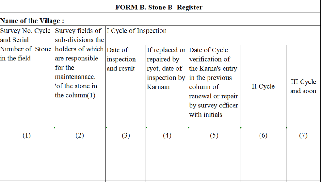
B. Procedure for making B-Class Stone Register:
The survey number and the stone number in that survey number should be entered in the first column of this register. The survey number and subdivision number of the farmer responsible for protecting the stone should be shown in the second column. When the officer inspects the stone, the date of inspection of the stone and the condition of the stone should be recorded in the third column. If the stone is missing, it should be recorded by the village assistant as the date on which the stone was inspected by the village assistant (renewed or not repaired or rehabilitated by the landowner) in the Fourth column. The date of replanting of the missing stone by the Survey Officer in the 5th column and the stones entered by the Village Revenue Officer Assistant in the 4th column should be recorded by the Survey Officer after inspection.
C. Systematic inspection of survey stones planted on the ground:
We know the total number of A and B class stones we need to protect in the respective villages from the D-Sketch we made. The village officer should inspect the total survey stones in each village every year. The stones planted in any village are more in number to be preserved, therefore the inspection should be done within 2-3 years. However, it should be inspected every year for not less than 1000 stones. Although there are thousands of stones in a village, all the stones in the village should be inspected within 3 years if it is a village with wetlands, and within 5 years if it is a village with drylands. But the village officer should not inspect all the survey stones in the village in a single month. The Village Revenue Officer in each village has to decide to inspect the number of stones in any given month i.e. from any survey number to any survey number, this program is decided by the collector. This means that on the first page of the register of stones, the program as determined by the AD on behalf of the Collector should be recorded. The village officer should inspect the stones in the respective survey numbers in the respective month as per the program shown in the stone register and record the result of the inspection within the relevant 3rd column in the stone register.
At the end of each month, the village officer prepares notices under section 15 (i) of the Survey Boundaries Act and sends them to the concerned Mandal Surveyor for details of the stones inspected in the villages of the village and the Pattadars who are responsible for safeguarding the stones found during the inspection. The Mandal Surveyor will sign the notices and send them back to the Village officer for issuance to the concerned Pattadars. Notices should be issued to the concerned Pattadars and their signature or fingerprint should be taken in a register. This register is known as the Acknowledgment Register under Section 15 (2) of the Survey Boundaries Act.
When the surveyor stays in the village, notices are issued to the Pattadars responsible for any missing stones and only 15 days have elapsed before the stones are replanted, billed for the cost of planting prepared, and sent to the Tahsildar’s office.
D. Important things to keep in mind while inspecting the stones on the field:
- Are there any stones planted along the border of Poramboke? If yes check whether they are in the correct position or not? Or did the farmer move them a little further in the direction they should have been? It should be noted that. For this, find the measurement from the opposite stone, either with the help of calculation or with the help of a scale. Is the distance between the stones correct? Or not?
- When the stones are inspected, any stones that are ready to bend or fall, or if there are small bushes, mounds, etc., on the stone and the stone is not visible properly, should be repaired immediately by the village assistants.
- Did he inspect the stones that the village officer recorded as being inspected? Or was it only written as checked? The Mandal Surveyor should over-check that the stones he inspected should not be less than 10 percent.
Duties to be followed while restoring lost stones:
- Have notices been issued under Section 15 (i) of the Survey Boundaries Act to all Pattadars who are responsible for safeguarding the stone before restoring it? Have 15 days elapsed since the date of issue? Or not? It is important to note that only stones that have been within 15 days from the date of issue of the notice should be replanted.
- Wagers/workers should not be used, as measured and planted by village servants, when re-planting stones near Poramboke lands or other government department lands.
- The stone to be planted should be planted at the exact measurement as it is between the Patta land and Poramboke land.