
A detailed town survey was undertaken based on a resolution approved by the Municipal Council to bear two-thirds of the cost of the survey. Similarly, the street survey in the panchayat was undertaken based on a resolution passed by the Panchayat Board to bear one-third of the cost of the survey. In the case of the Municipality, the government bears the remaining one-third of the cost, and in the case of the panchayat, two-thirds of the cost. The main aim of this survey is to record huge encroachments, detect encroachments and take necessary action to remove them. The purpose of the panchayat survey is not only to survey the streets and private property but also to survey all private, government, and municipal lands. Every plot within a municipal township is surveyed, whether private or public, or municipal property. Records are maintained to detect encroachments and take action to remove them, to examine the changes that occur after the survey.
Municipal towns covered much area with houses, and such areas can be of the following types.
Therefore, the survey method followed for agricultural lands cannot be followed for such an area of town. Another difficult aspect of the survey is that every square meter of land in the town is highly valued, so more accuracy is required with the town survey. Encroachments in these areas are also high, they need to be recorded. We must also safeguard government and municipal interests. Even if permissible and can be licensed, the smallest temporary occupation on municipal lands is a source of revenue. As in the case with agricultural lands such as clubbing fields, the formation of survey fields and setting up G-lines is impossible in town survey. The only viable method is to follow traversing, as It is very much more expensive, but there is no alternative, and the high cost is worthwhile because of the very high value of the land.
If you have a look at any built-over area of a town, you will notice streets running around each block. So along these roads and streets, we ran our traverses. Thus, we get a complete closed circuit for each block, and from these traverses, we offset the points required to delimit the boundary of each property. The walls of buildings are always at right angles and with the points defining the limits of the property the built-over portion of the house can be measured separately and plotted.
In Bangalore, Bombay, and a few northeastern states, conducted Town surveys with a theodolite framework and plane table. In this method, the traverse mechanism is the same, but when identifying block sheets with the help of chain and cross-staff finding out offsets and, without recording measurement in records and fields in block sheets are identified automatically by using a plane table in the field. Although this is a relatively inexpensive method and there is no measurement on these block sheets. We need to determine the measurements from the plotted block map by using a scale for future maintenance work. Based on these measurements made according to the scale, any boundary in dispute will have to be re-demarcated. Hence, it is not such a reliable method. This violates the provision in the rules framed under the Survey and Boundaries act stating that we should prepare a measurement record upon completion of the survey. Therefore, we don’t follow this method. We identify offsets. with the help of chain and cross-staff and record them in block sheets. Let us see the various operations followed in the town survey.
1. Preparation of index map.
2. Boundary demarcation(A PROCESS).
3. Traverse Survey (B PROCESS).
4. Traverse computation and plotting (C AND D PROCESS).
5. Field demarcation (E PROCESS).
6. Field Measurement (F PROCESS).
7. Inspection Work.
8. Final check operations.
9. Mapping (G AND H PROCESS).
Table of Contents
ToggleThe Commissioner should publish the notification under Section 5 of the Survey and Boundaries Act. The Survey Officer, responsible for the town survey under section 6 (1) of the Act, publishes the notification. The town boundaries of which the cadastral survey(previously) did are fully/partially. According to the Gazette Notification, detailing the boundaries of the municipality, the responsible authorities of the municipality will conduct a joint inspection to identify the boundaries of the municipality in the maps of the villages which are fully or partially covered within the municipal limits. After that, the boundaries of the Wards in the town and the boundaries of the cadastral surveyed fields in the villages or parts of the villages which are merged in the town, and a sketch showing all the above are drawn according to a suitable scale. We should show old Theodolite stones according to the cadastral survey record and stones among the other survey numbers on this map. After that, select the blocks that divide the town for the town survey and identify them in tracing. The principles to be followed in the formation of blocks are as follows.
It is a thickly built-up area like a commercial complex, shopping complex, etc,. An Extent of 10 Acres and the Scale of the block map is 1:500.
Houses with compound walls/gardens will be covered in this block. An Extent of 40 Acres and the Scale of the block map is 1:1000.
Agricultural lands with scattered buildings will be covered in this block. An Extent of 160 Acres and the Scale of the block map is 1:2000.
In blocks, mixed areas i.e. nearly spaced structures, scattered structures and closed fields, the formation of blocks are based on the nature of greater part of area. Block boundaries should follow the old village boundaries as far as possible. If the village boundary is swept away by the construction activities around and cannot be re-demarcated, we should follow the nearest boundary. When block boundaries do not coincide with village boundaries, closed and medium-sized blocks should follow streets, roads, and rivers. Large streams of considerable width are to be divided into separate blocks based on the confluence points of the adjacent blocks. Large ponds, other government lands, or municipal lands should be created as separate blocks. Blocks should be as rectangular as possible so that maps can be drawn. Important topographical details also need to be identified.
Steps are then taken to set up the wards by following the following guidelines. As far as possible, blocks of the same description(closed/medium/open blocks) should be created as wards. The number of blocks that can be included in a Ward is depending on the plotting scale to be used. The formation of wards, with the same description of blocks, may not be continuous. It may therefore be necessary to form different description blocks into a single Ward. In such cases, Maps of wards are plotted on 96 cm x 64 cm rectangular sheets based on the scale and decision criteria for area will be the plotted total area. Except in some special cases, according to the rules prescribed, closed blocks should not be combined with open blocks to form wards. We can combine medium blocks with closed blocks or open blocks.
After determining the ward boundaries and block boundaries, each ward is required to create an Index Map showing the details below.
We numbered the Wards in Arabic numbers starting with 1, 2, 3, etc., and the blocks in Wards with English letters A, B, C, etc
We set theodolite stations at important bends on the block boundary and where three or more streets or roads meet, and the surveyor demarcates the boundaries of the blocks. These stones need to be planted 2 inches below the ground surface. Marking should be made on cement roads in a convenient way, For measurement work and for future maintenance. To determine the stones which are not visible on the ground surface, the near-permanent structures such as building corners, telegraph poles, telephone poles, etc., At least three permanent structures should be selected to determine the position of stones. The “Tie lines” should be measured from permanent structures to theodolite stations. Tie line helps to re-fix the theodolite stones in the town survey.
We recorded these measurements in a sketch and in a special field book called the “Tie Line” field book. These measurements are taken to the nearest centimeter.
From the index map, a sketch map should be prepares for each ward, roughly to a scale of 20 inches=1 mile. This sketch should show the block maps, distinguishing the old theodolite station from the new ones. The sketch map should show the approximate positions of all important buildings, temples, rivers, rail-roads and other important details. The blocks in each ward should be numbered consecutively from North-West corner.

A copy of sketch map and a copy of the field book showing only the Tie line measurements and no traverse distances, should be furnished to the surveyor who does the operation of theodolite. The outer boundary of the town should have been surveyed first. The survey should start from and close on old traverse work. The angles and distances should be entered in their proper places in the Tie line field books.
In several cases, minor streets or lanes will branch off from the main street which forms our block boundary and run through our block to the main street on the other side. In such cases, the branch streets and lanes can be surveyed by fixing chain survey stones at points along the traverse line to run through block boundaries. The points from where the minor streets and lanes branch off will be on straight lines connecting two theodolite stations and no additional Theodolite survey is, therefore, necessary to fix and plot the additional streets and lanes. However, it is observed that it is not possible, a normal traverse should be carried out. In closed blocks, Theodolite stations should not be more than 500 feet apart. However, in medium and open blocks, these stations are set up as far apart as possible following the general rules. We should plant theodolite stations on opposite sides of the road or street so that the traverse may run diagonally and facilitate measurement. The stones should be granite. They are three types.
The dimensions of theodolite stone is 45cm x 20cm x 20 cm (18”x8”x8”) with flat top on which a broad arrow should be deeply cut. The point of the arrow should be cut in the middle of the top of the stone and should serve as a plummet hole. They are located in the closed block and medium block.
The dimensions of the chain survey stone is 30cms 15cmx 15cm (1’x 6”x6”) by square with a St.George’s cross on the top and an arrow mark on the side.
The dimensions of the field stone is 60cm x 15cm x 15 cm (2’x6”x6”) With the arrow cut on one side.
The same procedure of village traverse is to be followed. We deal town and ward boundaries in the same manner as village boundaries in cadastral survey and block boundaries in the manner of Khandam boundaries. However, the allowable limit error is 1/2000 for town and ward boundaries and 1/1000 for block boundaries. A duplicate copy of the traverse plotting of each block should be prepared. We will trace the 3 copies from this Skeleton map. A copy of the plotted traverse sheet is to be used by the surveyor for the Rough Block Map. We then used the second copy for the Fair Block Map to be made in the office. The third Duplicate copy of the block traverse sheet should be used to create the Demarcation Sketch. Therefore, a plotted traverse sheet belonging to each block of traverse sheet(Triplicate copy) is sent to the office by the surveyor, Once the C and D processes are complete. The traverse of each block should be plotted in duplicate on the following scales.
The block boundaries should be plotted in the traverse plot of each ward, and the ward boundaries in the traverse plot of town. The senior draughtsman should carefully examine the squaring of each sheet and also the scale drawn upon the map.
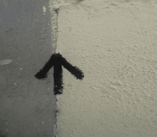
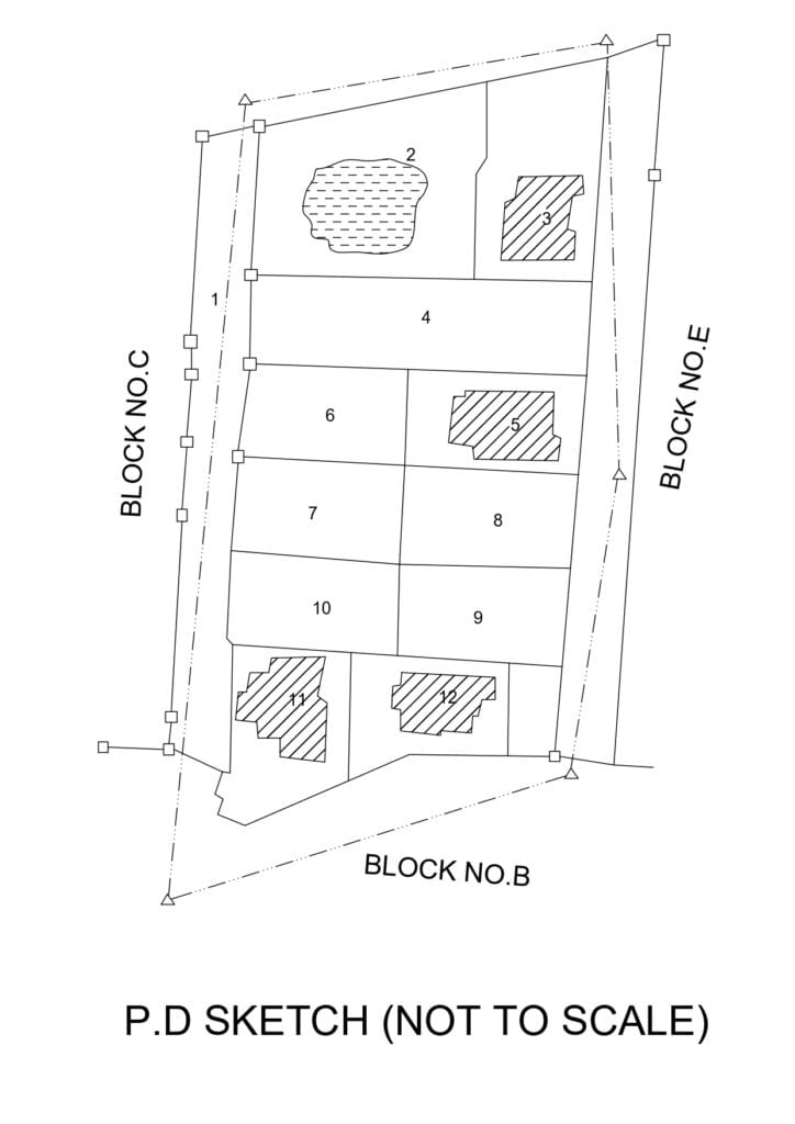
In this endeavour, the boundary examination of one asset, planting stones where necessary, and defining the boundaries. Where permanent masonry structures define boundaries of properties, no stones need to be plated, we should paint an upward arrow mark on the edge of the masonry structure. This type of permanent mark is called Tar Mark. Preparation of the land register, recording of encroachments within boundaries of streets and roads, preparation of encroachments registers, and lastly for every block of preliminary demarcation sketches (P D SKETCHES).
For this, before the demarcation begins, the assistant director should get from the municipal chairman the following three lists.
The tahsildar of taluk should also furnish a list of Government lands and a list of encroachments registered in revenue accounts to the AD survey. Survey staff should refer these lists to in the demarcation of properties. We should demarcate boundaries between streets or roads and private property in accordance with the accounts. We should remove all encroachments from private property. All poramboke boundaries should be re-demarcated as per old survey records. If any encroachments should be recorded subject to Street alignment activities, it must show all Street encroachments in a skeleton traverse plot. A duplicate copy of this plot should be sent to a special officer appointed to conduct such activities. We should set no boundary for these types of encroachments.
Each individual or jointly owned plot of land, even if it has no structures, should be identified as a separate survey field. This should also apply to government lands, municipal lands, and government lands assigned to the municipality i.e. roads, streets, etc., we should start numbering the survey field in the block from the northwest corner and finished at the southeast corner. The field register should be written up from revenue accounts of villages within the town and the House-tax registers of the municipality. There are many instances in cities where different floors of the same building are owned by different people. Although survey activities are primarily concerned with the owner of the area, where the building is constructed and encroachments recorded on the roadside. Therefore, we have to register the name of the owners of each building/structure. In such cases, in the relevant column of the land register, the name of the owner of the ground floor should be entered in front of the relevant town survey number and the names of owners of the remaining floors i.e, The first floor, second floor, etc. should also be entered separately with additional remarks. In the case of structure, the type of the structure i.e. terrace, kutcha house, or pucca house is written in the column of remarks opposite the relevant town survey number in the register.
The block demarcation sketch should show all boundaries of the survey field in black ink. We should indicate encroachments with red ink and with broken lines. We should indicate the shape of encroachments with yellow ink. The numbering of encroachments also needs to be completed in a row for each block. A separate encroachment register needs to be created for each block. Complete details of encroachment such as row number, house number, encroacher name, nature of encroacher, encroachment diagram, and encroachment area should be provided in this register.
From all properties, all encroachments made by the owner are assigned a single case number and shown in the PD sketch. The encroachments in streets should be indicated by blue ink.
The surveyor should make the following records as soon as boundary demarcation completes.
1. Preliminary demarcation sketch.
2. Land register.
3. Correlation statement.
4. Encroachment register.
5. Stone account notices are sent to registered holders.
All lines of field are measured. We adjust these measurements to the nearest centimeter and recorded them. With private property, sometimes, the common wall may belong to a single house. In other cases, it may be common for two houses. The surveyor will draw a thin Red line along the boundary to show which house it belongs to in survey records. If that red line doesn’t exist, we understand it belongs to the houses jointly. Measuring the boundaries of the property facing streets or roads and the offset of bends facing roads and streets is easier than measuring the boundaries of bends on the other side of the property. In most of these cases, the surveyor has to take a RAY LINE at a fixed center on the traverse line with the help of a cross-staff where there is no barrier, identify the offset of bends, and calculate the distances. In such cases, the surveyor must show great patience and intelligence. This is because he faces many practical difficulties in completing the measurement work in populated areas such as old towns and bazaars where houses are built following no urban planning rules, especially in closed blocks in the town.
The Officer-in-Charge should ask the Municipal Commissioner and the Traffic Officers to close the traffic for a few hours as it is very difficult for the surveyor to carry out the measurement on a road with extreme traffic congestion as all the offsets have to be identified on the traverse line of measure to be measured across the roads. In the case of all boundary lines, the measurement is rounded off to the nearest metric link, i.e. 20 cm. However, in the case of rows of houses, they are recorded in links and centimeters, so that we can adjust them before creating a Rough Block Map.
In the case of measuring houses, we should bear it in mind that the measurements taken for each house should clearly state whether the wall width is included or not. Traverse lines should be carefully measured. For Property bends, other bends offset should be taken on both sides of chain lines. If it is realised that it is not workable to take offsets directly from the traverse lines to the interior bends, then the arbitrary G-line is drawn between the two manageable centres that determine their positions on the traverse lines, and then the offsets are perceived. In the open block, the D&O method is followed to produce independent plottable data for the survey fields. In such cases, we must take care not to reduce the measurement work by forming large triangles. Small area survey numbers can be measured by drawing a single G-line across that area.
All field-level Trijunction stations are required to determine the offsets on the block traverse mechanism. All the bends on the boundaries of each enjoyment have to be marked with stones for a long time. Plottable data is not required for encroachments. It is sufficient to provide sufficient data based on the F-line. Thus, the encroachments have to be localised at a later date.
Most of the encroachments are rectangular. We also recorded measurements based on the F-line adjacent to the encroachments. We must properly record the measurements taken for the encroachments in the metric links. Roads, roads, etc., All the important details have to be determined by the offset on the traverse line. Similarly, with Town survey numbers, the offsets must be grasped so that we can properly depict them on the Town map. For areas with structures i.e. closed and medium-sized blocks, structures divisions and empty divisions need to be properly surveyed and identified on the map. Therefore, in this Town survey number, offsets have to be taken for the important bends of the structures divisions. Thus, it has to be printed like that. Concerning closed, medium-sized blocks, there is no question of equalising small bends in the Town survey. Housing Board for Military Officers, If there are no government roads between the colonies of houses belonging to such, it is sufficient to sketch the block of houses on either side of the roads passing through those colonies. Ownership of houses in such colonies is institutional. So it is unnecessary to survey every house.
As the measurement work progresses, the surveyor identifies the fields in a triplicate copy of the Traverse skeleton plot supplied to him by the office. This is called a plotted demarcation sketch. As soon as we identified each field after the measurement is completed, the field boundaries measurement and the traverse lines are noted in the sketch. The offsets on the G-line are noted separately in the ladder. The surveyor is expected to compile a list of discrepancies observed in the registry for each survey number while conducting the measurement. Similarly, if he notices any discrepancies with the encroachments, he takes note of it and submits a list of such matters to the inspection officer. The plotted demarcation sketch contains the same details as in P.D Sketch. But there is a difference between the two. In this plotted demarcation sketch, the Town survey number, all the measurements related to the encroachments as well, P. D sketch is a sketch that shows details other than dimensions, this is the difference between the two.
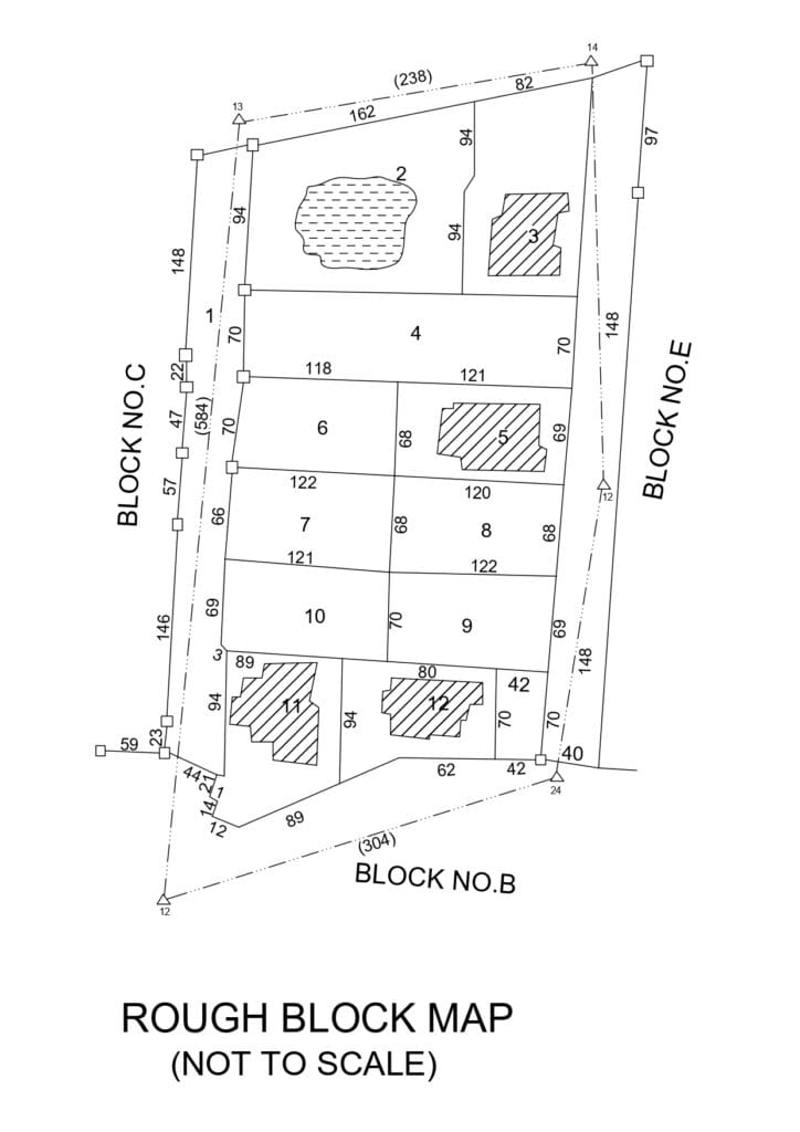
He also created a Rough Block Map while preparing a plotted demarcation sketch. The traverse skeleton map supplied by the office is to be traced on a determined scale. The rough block map should contain all the details shown in the ‘plotted demarcation sketch’, except for measurements taken for walls and encroachments. After completing the plotting work of the Rough block map, the Surveyor prepares a Rough Area List. We usually calculate the survey area with the help of area square paper and in the office with the help of a computing scale. After completing the measurement work for each block, the surveyor is required to submit the following records.
At the end of the inspection, while conducting the measurement, he will return the following records sent to him as a guide.
As soon as we completed the measurement work for each block, the inspectors of different ranks are required to complete the percentage of their inspections.
A special Revenue Officer will be appointed to determine the boundaries of government lands and to inspect and finalise the registry. The following functions are specifically assigned in the Survey Manual for the Appointed Special officer.
After the final inspection by the Special Revenue Officer is completed, the records are carefully inspected at the office. Next, a single fair block map is created with the dimensions recorded in the rough block map. Areas are calculated using computing scales and area squares and are recorded in hectares, Ares, and square meters. An area list should be prepared. In the land register, the areas opposite each town survey number are also recorded. The total area of each block is recorded in the fair block map. The area of traverse is compared to the area of fields and the difference should be 1%.
After the completion of the mapping of all the blocks of the ward, the Revenue mapping and ward mapping work will be undertaken. The revenue map simply shows all the urban survey numbers and the topo details in the block without any measurement. It is just a guide map, like the village map. We trace this like the fair block map scale. Similarly, with the same details, a lower-scale ward map is also traced.

The above-mentioned measurement sheet record is for tracing only to a fair block map.